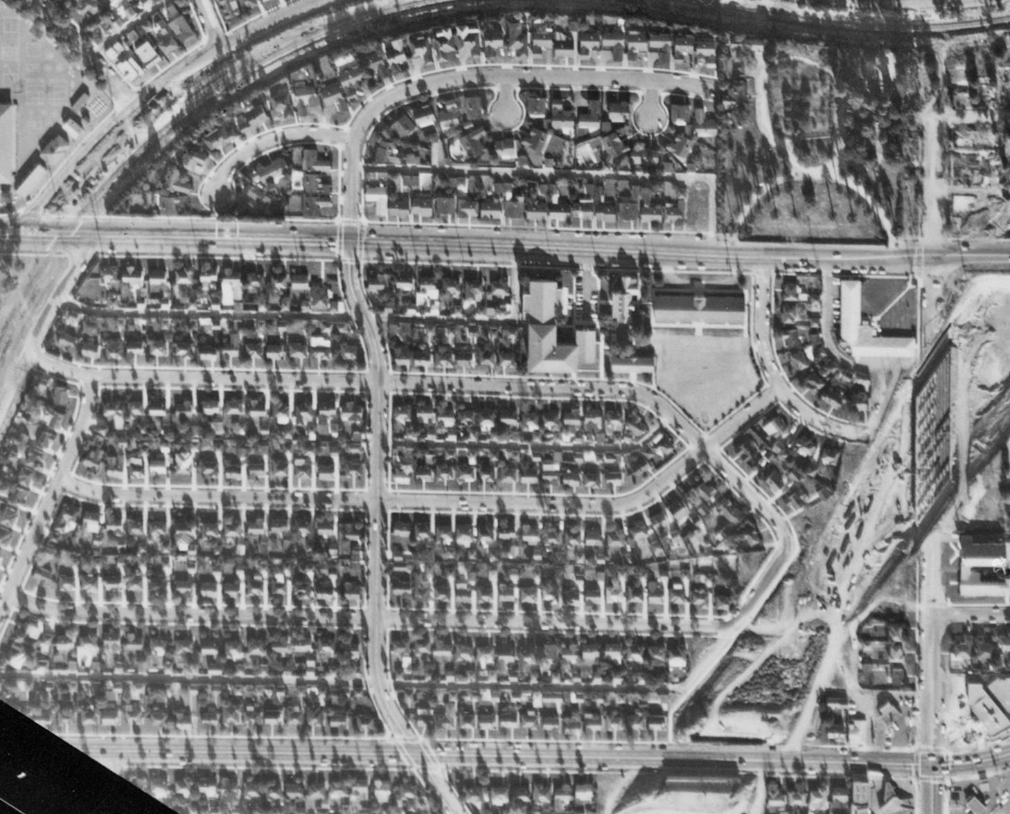
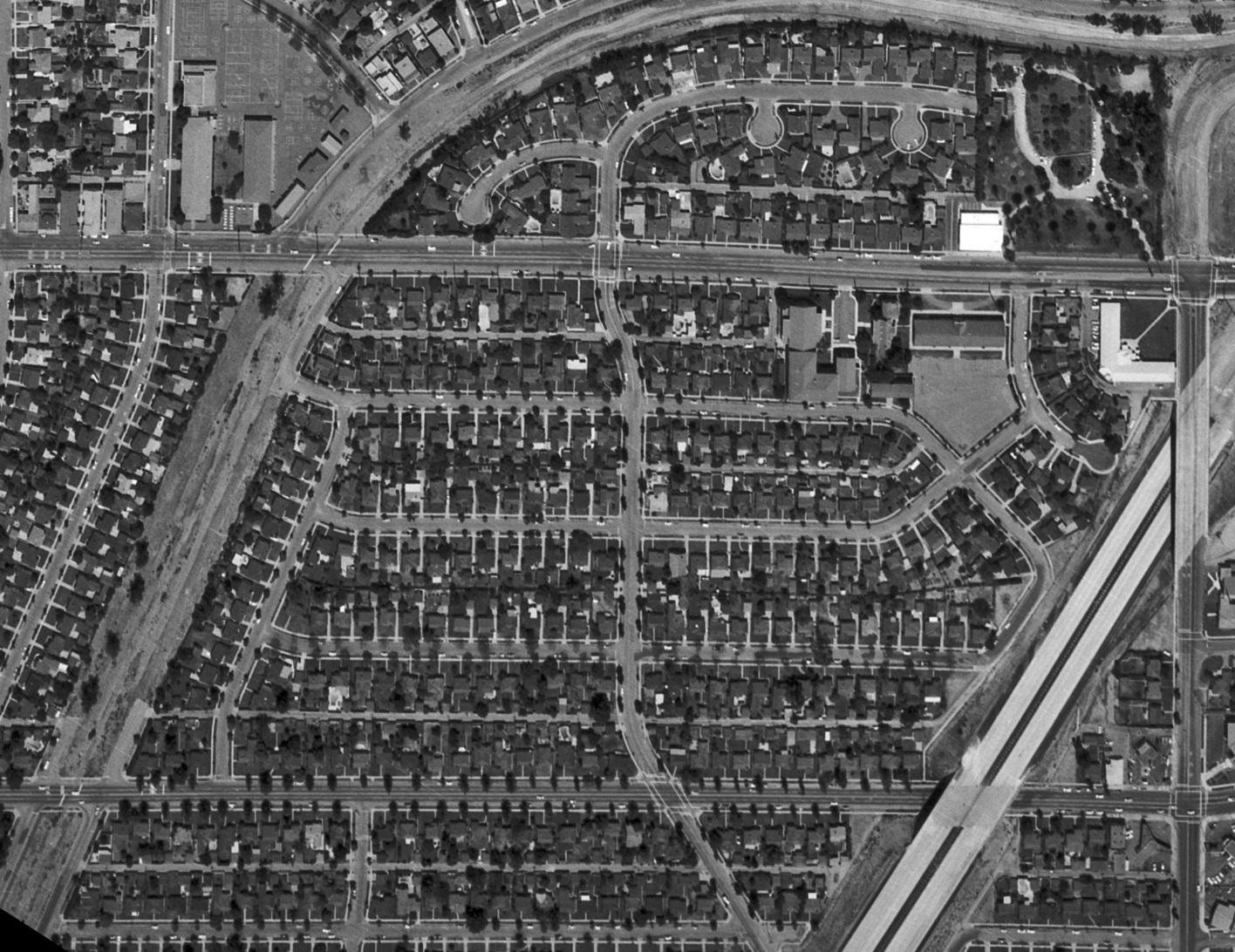
Westwood Gardens is a mid-1940s West Los Angeles subdivision comprising five tracts (12376, 12382, 12388, 12397, 13037). It is built in the northeast section of the Rancho La Ballona (1839-1868), occupying most of lots 1-6 of the 1875, 19-lot tract John D. Young, shown below.

Westwood Gardens was built by a partnership of wartime “merchant builders“: Paul Trousdale, Jr., Hyatt Robert Von Dehn, and William Godshall, operating as the Housing Construction Company (HCC) and the Overland Housing Co. Together with “Sepulveda Gardens” and “Lakewood Gardens,” Westwood Gardens was one of Mr. Trousdale’s three “Gardens” subdivisions.
The Westwood Gardens subdivision sits between earlier-developed residential neighborhoods: Ambassador Park (1923) immediately west, Westwood Hills (1923) north across Pico Boulevard, and Country Club Highlands (1923) east across Overland Avenue. Those earlier tracts were heavily promoted (bands, movie stars, giveaways), yet they still did not sell out before World War II. With the post-war housing shortage, low prices from mass production, and special terms for veterans (the VA loan program was part of the original Servicemen’s Readjustment Act of 1944, also known as the World War II GI Bill) Westwood Gardens’ houses were all sold in half a year – apparently without even a single newspaper advertisement. Like the earlier tracts, racially restrictive covenants covered the property, requiring that “no person of any race other than of the white or Cacasian [sic] race shall use or occupy any building or any lot” while allowing “occupancy by domestic servants or any other race domiciled with an owner or a tenant.“
Tract Limits
Overland Avenue limits Westwood Gardens on the east while the subdivision extends west to homes on the west side of Midvale Avenue; it includes homes on the south side of Ayres Avenue on the north and those the north side of National Boulevard to the south. The neighborhood’s land was annexed to the City of Los Angeles piecemeal. The Palms Annexation added the railroad land on May 21, 1915; the Westgate Annexation took land north of the railway on June 13, 1916; and, on March 5, 1927, the Mar Vista Addition included the land to the south. Westwood Gardens is an integral part of Rancho Park, so-named by business interests in the years immediately before World War II to distinguish the district from the Westwood community to the north. Westwood Gardens’ sidewalks are stamped, “J. E. Haddock Ltd.” and “1945.”


What Came Before?
The first private ownership was as Rancho La Ballona (1839-1868) granted by Mexico to brothers Agustín and José Machado and to father and son Felipe and Tomás Talamantes, who owned all of the land together; nobody owned any particular sections. When Tomás Talamantes could not pay on a loan, La Ballona was partitioned. John D. Young (1843-1915), who filed the lawsuit to partition the land, was one of the beneficiaries. He subdivided the section that would later hold Westwood Gardens on November 1875, the month after the Los Angeles and Independence Railroad began to run across his land and sold parcels throughout his life.
North of the railroad, most of the land up to Pico Boulevard held a blue gum tree farm between about 1887 and 1890. (L. A. Times, That Blue Gum Story (Aug. 5, 1891); L. A. Evening Express, A Clear Statement, the Contract between Dr. Elliott and his Wife (Sept. 1, 1891).) In the next century, Ferdinand Bain’s Rancho La Lomita covered the land south of the railroad between 1919 and 1939. The northwest section held the world’s second permanent drive-in movie theatre from 1934 through 1944.
In 1939, Paramount Pictures bought Rancho La Lomita’s 90 acres after a bank foreclosure, as well as Magdalena Wolfskill Sabichi’s (1846-1930) 60 acres north of the Southern Pacific tracks to Pico Boulevard, for “Paramount City.” Abandoning its plans, Paramount sold most of the land to the Westwood Gardens developers in 1944. In 1945, it sold 2 1/2 acres to the Catholic Archdiocese for the Sisters of Notre Dame‘s schools. (The Archdiocese promptly bought additional space from the developers to expand the school.)
Paramount sold a large chunk along Pico Boulevard to “oilmen” Edwin W. Pauley and Harold Pauley in 1948.
Bids for construction of the first three buildings in a $5,000,000 shopping district to be called Pico-Westwood business center are to be received immediately, the owners, Edwin W. Pauley and Harold Pauley announced today.
L. A. Evening Citizen News, Westwood Shopping Center Bids Asked (Nov. 15, 1948).
Planned to include department, chain, variety and specialty stores and shops, the new business district will extend along 1600 feet of frontage on the south side of Pico Blvd. between Overland and Midvale Aves. and bisected by Westwood Boulevard. A theater is to be constructed on a site sold previously to other interests.
Three buildings worth $1,250,000 will comprise the first unit and will be occupied by the Owl Drug Co., Von’s Grocery Co. and the J. J. Newberry Co.
In 1963, Pauley announced construction of a May Co. department store at Pico Boulevard and Overland Avenue – the east end of their “Pico-Westwood business center.” (L. A. Evening Citizen News, July 29, 1963.)

Sister “Gardens” neighborhoods: Lakewood Gardens & Sepulveda Gardens
Trousdale appended the name “gardens” to two of his other developments: Lakewood Gardens and Sepulveda Gardens. The Lakewood Gardens Civic Association, incorporated in December 1947, says: “Lakewood Gardens was built in 1946-1947 by a developer named Paul Trousdale. It is bounded on the north by Ashworth Street, on the east of Lakewood Boulevard, on the south by South Street, and on the west by Hayter Avenue. There are 452 homes in this area.”
Sepulveda Gardens was a six block “G.I. housing development,” from Noble Avenue westerly to Sepulveda Boulevard, Trousdale completed in 1947. (The Van Nuys News, Pitch-Putt Golf Course Site Inspection Planned (Nov. 10, 1949).)

Ponty Tract
In 1951, George Ponty developed tract 17263: 61 homes across Overland from Westwood Gardens, north of the Rainey property. He had learned building under his father, Spyros George Ponty who, in the 1930s, built over a third of the homes in Los Angeles’ South Carthay neighborhood, which would later be covered by an Historic Preservation Overlay Zone preserving Spyros’ unique Spanish Colonial Revival houses.
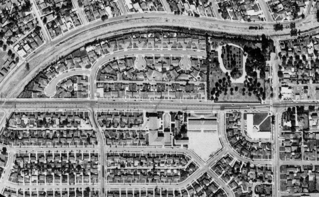
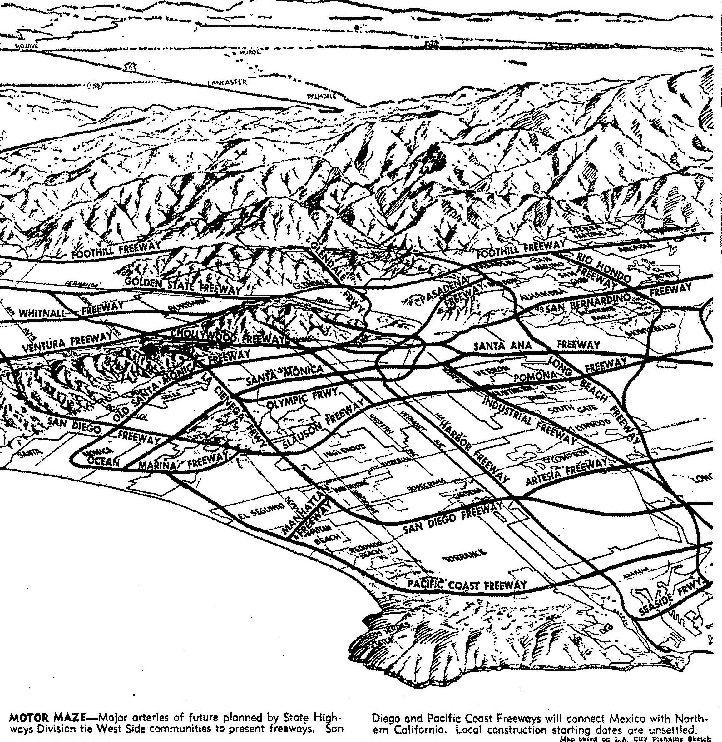
Freeway Cuts a Swath (early-1960s)
As early as 1955, the Westwood Gardens Civic Association (among other groups) protested what was then proposed as the “Olympic Freeway.” Their Assemblymember went to bat for them, but to no avail:
A 30-year-old freshman legislator, bucking urgent appeals for early construction of the Olympic Freeway, yesterday carried the fight against routing of the disputed superhighway through West Los Angeles to the State Highway Commission.
Freeway Will Ruin Homes, Board Told – Residential Areas on 80% of Route, Legislator Claims (L. A. Times, Sept. 30, 1955).
Thomas M. Rees of the 59th Assembly District charged at a public hearing in the State Building that 80% of the route recommended by the State Division of Highways would cut through residential areas of Rancho Park and West Los Angeles, none more than 10 years old.
Rees . . . contended that the proposed Olympic Freeway route would split the Rancho Park community.
“It would constitute a wall diagonally across this area,” he declared. “As it is set up now, it comes within a few hundred yards of three schools and just as close to a new grammar school and a new high school.”
Ultimately, the freeway curved away from homes in the in newer, the more affluent Cheviot Hills tracts: Cheviot Knolls (1938) and California County Club Estates (1951).

“Paper Streets” become Westwood Neighborhood Greenway (2020)
In 2009, designers of Los Angeles County Metropolitan Transportation Authority’s Expo (later “E”) Line proposed parking lots for the development’s “paper streets” – land Westwood Gardens’ developers had dedicated for future streets, which remained unbuilt.
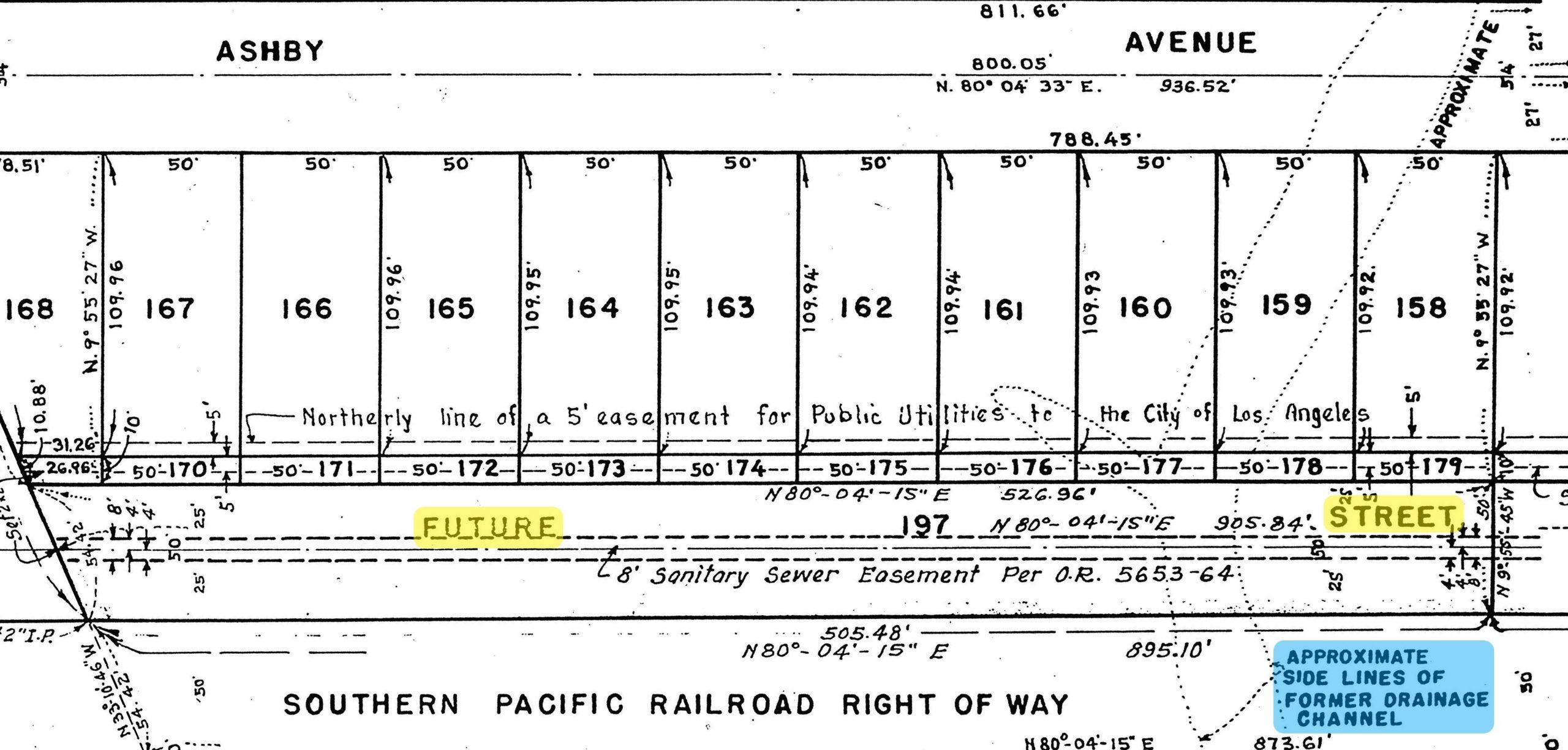
In 2020, after years of effort by neighbors and the WGCA, the paper streets became the Westwood Neighborhood Greenway. There, Brown Canyon Creek, which previously carried trash and other pollution through storm drains to the ocean, is pumped into a revived stream through two acres of restored native landscape where it is cleaned.


The City of Los Angeles project was supported by (among others) State Senators Sheila Kuehl and Holly Mitchell, State Representative Diane Watson, the Natural Resources Defense Council, Sierra Club, Heal the Bay, the California Botanic Garden, and the California Native Plant Society and funded through Proposition O, Proposition 84, and the Santa Monica Bay Restoration Commission through an agreement with the California State Water Resources Control Board. It is operated by the Los Angeles Department of Sanitation & Environment with the support and participation of Westwood Greenway, Inc., a non-profit formed by those activists who conceived of the Greenway and worked for nearly 14 years to get it built.